Bømlo to Haugesund - 27th May
The small campsite in Leirvik was my introduction to the NAFcamp organisation. The NAF is the Norwegian equivalent of the AA or the RAC, but they also produce an excellent campsite guide with a very good general map of Norway. The guide is free from any NAF campsite.
I met Gunther on the campsite. He was a little gloomy. Seventy years old, and estranged from his family, he warned me that the decade between sixty and seventy had aged him twenty years. Even so, he aimed to cycle 2000km every month. He was pessimistic about the weather, too, but as I cycled away from Leirvik over the huge bridges that led to the island of Bømlo the sun came out. The road snaked around the heads of small inlets of the sea and it rained off and on, but in a not-unenjoyable way. I stopped at a petrol station for coffee and sat in the sun to let my jacket steam dry and a passer-by ordered me to turn my face to the sun. I was wasting a golden opportunity!
 |
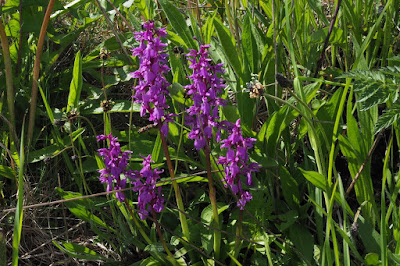
| Orchids on Bømlo |
The island of Bømlo is very beautiful. The road rises and falls steeply between jagged outcrops of rock, dotted with small lochans where waterlilies grow. They weren't out yet, but the marsh marigolds were gleaming golden yellow in almost every ditch. There were primroses too, and violets, and wood anemones and cuckoo flowers, but the flower of the day, of the week even, was the dandelion. They were everywhere.
 |
| On the road to Haugesund |
At Langevåg I arrived at the ferry terminal to find the timetable obscured by condensation in its glass case. There was no one about so I sat down in the sunshine to eat my lunch. I'd just started making a cup of tea when cars started rolling up, closely followed by the ferry, so I packed up quickly and got on board.
Back on the mainland the road was still quiet and beautiful, but less steep, and I cycled through the afternoon to the campsite just north of Haugesund. It was closed for the winter. That didn't stop someone from showing up to collect money though, and to dispense keys to the toilet block, and wifi codes.
It looked like rain. The map on AllTrails is here.
Tips:
- NAF for campsite guide and map.
- Closed does not always mean closed.
- Visit a Tourist Information office when you can and pick up as many ferry timetables as possible.


Comments
Post a Comment